GeoSLAM ZEB-REVO Real-Time for sale, GeoSLAM Hub Software with Licence dongle, 1 Year Geoslam Warranty
GeoSLAM ZEB-REVO Real-Time for sale, GeoSLAM Hub Software with Licence dongle, 1 Year Geoslam Warranty
GeoSLAM ZEB-REVO RT for sale includes:
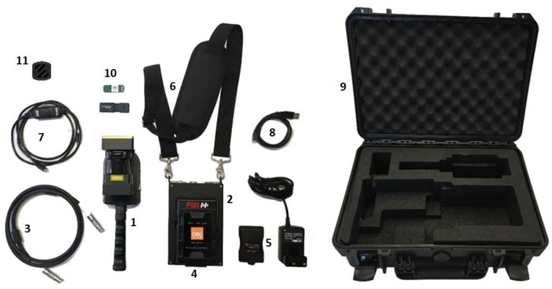
GeoSLAM ZEB-REVO RT Parts
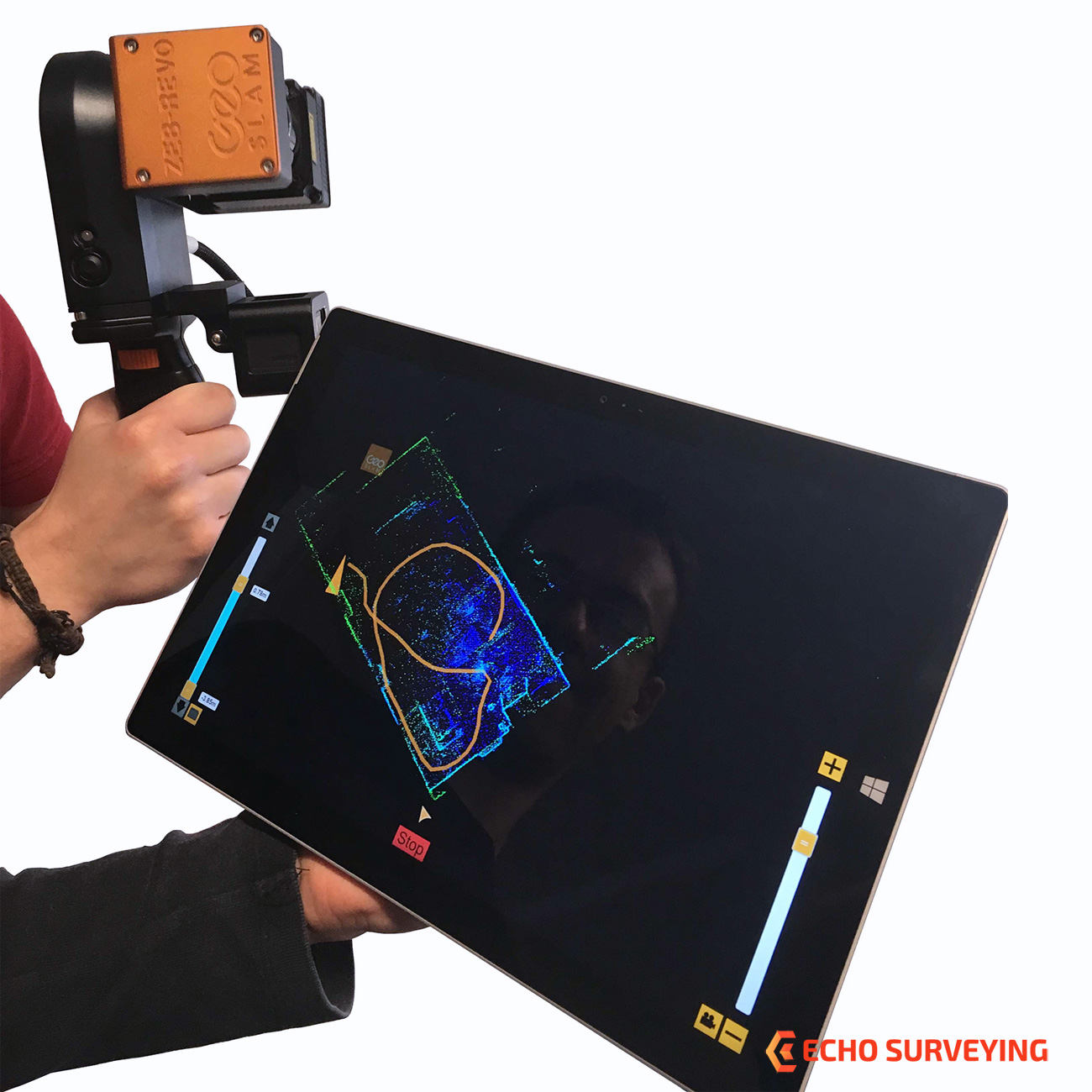
GeoSLAM ZEB-REVO RT is a handheld mapping system which can be used in many environments, particularly indoor, underground or hard to reach areas. Allowing you to scan & process simultaneously, as you walk Real-Time.
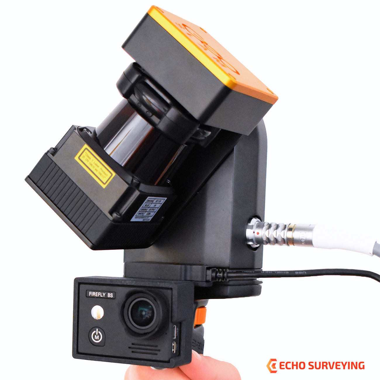
Optional add-on video camera GeoSlam ZEB-CAM Firefly 8S for the ZEB-REVO. ZEB-CAM incorporates a Hawkeye Firefly 8S action video camera. The image data collected by the camera can be viewed alongside the 3D point cloud created by the ZEB-REVO and used to extract contextual information. Simply attach the ZEB-CAM to the underside of your standard REVO unit and begin scanning. ZEB-CAM captures live video footage of your survey environment as you walk and scan. Optical flow technology is utilised to accurately synchronise the video and scan data together in GeoSLAM’s Hub software.
ZEB-REVO RT Solution
The brand new realtime solution from the experts in “go-anywhere” 3D mobile mapping technology. Handheld, lightweight and easy to use laser scanners that allow you to rapidly collect and process scan data, simultaneously whilst on the move.
go-anywhere’ 3D mobile mapping – Data capture with our products is as simple as ‘walk and scan’. Map a 3-storey building in just 30 minutes to an accuracy level of 15mm or scan, view and export up to 10,000 m2 (105,000 sq. ft.) in under 1 hour. Join our customers as they measure building plans 10 times faster than traditional tools, deliver BIM models earlier than expected and experience project cost savings of up to two thirds. And with our solution, customers can expand their range and scope of services by taking on projects that would otherwise have proved too difficult or time consuming using traditional survey techniques.
“go-anywhere” 3D mobile mapping – our versatile technology is adaptable to any environment in all industries, especially complex and enclosed spaces, without the need for GNSS. Flexible mounts and deployment options means that GeoSLAM hardware can be handheld, drone or robot mounted or even attached to a pole or cable. Weighing only 3.5kg, the handheld device can be used to quickly scan multi-level environments, and with ratings up to IP64 level, our technology is designed for use in hazardous and harsh environments.
Rapid scanning time – within minutes anyone can be operating GeoSLAM tech, and our intelligent software (which uses the most established and robust SLAM mapping algorithm in the industry) can map a 3-storey building in just 30 minutes to an accuracy level of 15mm, or map a 10,000 m2 (105,000 sq. ft.) depot in under an hour. Walk through your target survey environment to record more than 43,000 measurement pts/sec, and from scan to full 3D BIM model in under an hour!
Saving you time and money – you can capture and model complex data up to 10 times faster, enabling you to successfully complete projects in minimum time with little or no disruption at the project site. With proven ability to scan faster than traditional surveys or static terrestrial laser scanning, you can reduce scanning time, in many cases by half. Customers often find that the ZEB-REVO or ZEB-REVO RT is highly complementary to their existing scanning hardware, as the combination allows indoor handheld scanning to take place at the same time as the outdoor scanning, saving project time and money.
SPECIFICATION