
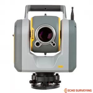
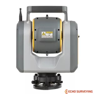
Trimble SX12 Scanning Total Station with Wi-Fi HaLow Radio, Work robotically, Reliable, long-range radios are the invisible backbone of robotic total stations
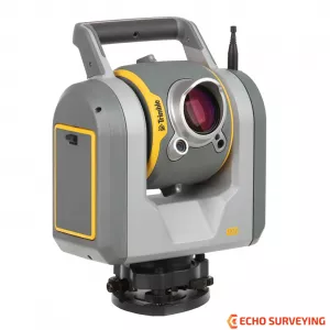
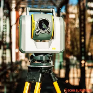
The introduction of the Trimble SX12, Reliable, long-range radios are the invisible backbone of robotic total stations today.Trimble SX12 with Wi-Fi HaLow model now brings the benefits of this radio to Trimble users, allowing the SX12 to quickly and easily work robotically, including at long ranges. With the NEW Trimble SX12 3D Scanning Total Station, working harder has never been easier. It combines innovative technology with simple and intuitive functionality to help you save time, maximize efficiency and get more done in the field. The SX12 is the one instrument you need to handle any surveying project by integrating surveying, imaging and 3D scanning capabilities into your everyday workflow
Now Trimble SX12 equipped with Wi-Fi HaLow radio technology
Wi-Fi Halow provides a more reliable and robust connection—up to 14 times higher bandwidth than long-range radio. It makes it easy to complete data-heavy tasks like scanning transfers or video streaming.
Wi-Fi HaLow is a variation of Wi-Fi that operates at a different frequency band, providing a longer range but lower throughput compared to standard Wi-Fi. It's similar to the difference between 2.4 GHz and 5 GHz Wi-Fi frequencies commonly found in home routers.
High accuracy total station, high quality scan data
Quick data capture, even at long range
Vivid, eye-safe laser pointer
Simple navigation and documentation with Trimble VISION™ camera system: Three integrated and calibrated cameras in the telescope
Applications
Software
Trimble Business Center lets you fully integrate Trimble SX12 data into your projects using the familiar workflows of the marketing leading survey office software. Enhanced point cloud management, automated extraction and interoperability to leading CAD and GIS packages ensures that you can satisfy even your toughest client demands.
The Trimble Tablet Rugged PC operates the feature rich, intuitive Trimble Access field software. Streamlined workflows guide crews through common project types, helping to get the job done faster with less distractions. Trimble Access workflows can also be customized to fit your needs.
Back in the office, trust Trimble Business Center software to help you check, process and adjust your optical, leveling, and GNSS data in one software solution. No matter what Trimble instruments you use in the field, you can trust that Trimble Business Center office software will help you generate industry-leading deliverables.
FEATURES AND CAPABILITIES
INDUSTRIES AND APPLICATIONS
| TRIMBLE SX12 SCANNING TOTAL STATION DATASHEET | ||
| SURVEY PERFORMANCE | ||
| ANGLE MEASUREMENT | ||
| Sensor type | Absolute encoder with diametrical reading | |
| Angle measurement accuracy | ” (0.3 mgon) | |
| Angle display (least count) | 0.1” (0.01 mgon) | |
| AUTOMATIC LEVEL COMPENSATOR | ||
| Type | Centered dual-axis | |
| Accuracy | 0.5” (0.15 mgon) | |
| Range | ±5.4’ (±100 mgon) | |
| Electronic 2-axis level, with a resolution of | 0.3” (0.1 mgon) | |
| Circular level in tribrach | 8’/2 mm | |
| DISTANCE MEASUREMENT | ||
| Accuracy | ||
|
Standard Tracking |
1 mm + 1.5 ppm 2 mm + 1.5 ppm |
|
Standard | 2 mm + 1.5 ppm |
| Measuring time | ||
|
|
|
| Range | ||
| Prism mode | 1 prism | 1 m–5,500 m |
| DR mode |
|
|
| Autolock® and Robotic Range | ||
| Autolock range - traverse 50 mm | 1 m–800 m | |
| Autolock range - 360 prism | 1 m–300 m 6 / 700 m | |
| Angle accuracy1 | 1” | |
| SCANNING PERFORMANCE | ||
| GENERAL SCANNING SPECIFICATIONS | ||
| Scanning principle | Band scanning using rotating prism in telescope | |
| Measurement rate | 26.6 kHz | |
| Point spacing | 6.25 mm, 12.5 mm, 25 mm or 50 mm @ 50 m | |
| Field-of-view | 360° x 300° | |
| Coarse scan; Full Dome - 360° x 300° Density: 1 mrad, 50 mm spacing @ 50 m |
Scan time: 12 minutes | |
| Standard scan; Area Scan - 90° x 45° Density: 0.5 mrad, 25 mm spacing @ 50 m |
Scan time: 6 minutes | |
| RANGE MEASUREMENT | ||
| Range principl | Ultra-high speed time-of-flight powered by Trimble Lightning technology | |
| Range | ||
| Kodak White Card (Catalog number E1527795) | 0.9 m–600 m | |
| Kodak Gray Card (Catalog number E1527795) | 0.9 m–350 m | |
| Range noise | ||
| @ 50 m on 18–90% reflectivity | 1.5 mm | |
| @ 120 m on 18–90% reflectivity | 1.5 mm | |
| @ 200 m on 18–90% reflectivity | 1.5 mm | |
| @ 300 m on 18–90% reflectivity | 2.5 mm | |
| Scanning Accuracy | ||
| Scanning Angular Accuracy | 5” (1.5 mgon) | |
| 3D position Accuracy @ 100 m | 2.5 mm | |
| EDM SPECIFICATION | ||
| Light source | Pulsed laser 1550 nm; Laser class 1M | |
| Beam divergence DR mode | 0.2 mrad | |
| Laser spot size at 100 m (FWHM) | 14 mm | |
| Atmospheric correction | Available through field and office software | |
| Color | Green, 520 nm | |
| Eye Safety | Laser Class 1 | |
| Focusing | Automatic, Manual | |
| Operating modes | Low-light, Standard, Extended Range Flashing | |
| Laser Pointer Spot Size (Full Width Half Maximum) | ||
| 1.3 - 50 m | 3 mm ± 1 mm | |
| 100 m | 6 mm ± 1 mm | |
| 150 m | 9 mm ± 1 mm | |
| IMAGING PERFORMANCE | ||
| Imaging principle | 3 calibrated cameras in telescope powered by Trimble VISION technology | |
| Cameras total field of view | 360° x 300° | |
| Live view frame rate (depending on connection) | Up to 15 fps | |
| File size of one total panorama with overview camer | 15 MB–35 MB | |
| Panorama Measurement Time and Resolution | ||
|
Full dome 360° x 300° with 10% overlap | 2.5 mins, 40 images, 15 mm @ 50 m per pixel |
|
Area capture 90° x 45° with 10 % overlap | 2.5 mins, 48 images, 3.5 mm @ 50 m per pixel |
| CAMERAS SPECIFICATIONS | ||
| General Camera Specifications | ||
| Resolution of each camera chip | 8.1 MP (3296 x 2472 pix) | |
| File format of images | .jpeg | |
| Field of view max | 57.5° (horizontal) x 43.0° (vertical) | |
| Field of view min | 0.51° (horizontal) x 0.38° (vertical) | |
| Total zoom (no interpolation) | 107 x | |
| 35 mm equivalent focal length | 36–3850 mm | |
| Exposure modes | Auto, spot exposure | |
| Manual exposure brightness | ±5 steps | |
| White balance modes | Auto, daylight, incandescent, overcast | |
| Temperature compensated optics | Yes | |
| Calibrated cameras | Yes | |
| Overview Camera | ||
| Position | Parallel to measurement axis | |
| One pixel corresponds to | 15 mm @ 50 m | |
| Primary Camera | ||
| Position | Parallel to measurement axis | |
| One pixel corresponds to | 3.5 mm @ 50 m | |
| Telescope Camera | ||
| Position | Coaxial | |
| Focusing | Automatic, manual | |
| Focusing distance | 1.7 m to infinity | |
| One pixel corresponds to | 0.69 mm @ 50 m | |
| Pointing precision (std dev 1 sigma) | 1” (HA: 1,5 cc, VA: 2,7 cc) | |
| Plummet Camera | ||
| Usable range | 1.0–2.5 m | |
| Resolution on ground - one pixel corresponds to | 0.2 mm @ 1.55 m instrument height | |
| Accuracy | 0.5 mm @ 1.55 m instrument height | |
| COMMUNICATION | ||
| Communication | Wi-Fi, Wi-Fi HaLow™ , 2.4 GHz Spread Spectrum, cabled (USB 2.0) | |
| Wi-Fi/WLAN operating frequencies | 2412–2462 MHz | |
| Wi-Fi HaLow operating frequencies | 902–928 MHz | |
| FHSS Long Range Radio operating frequencies | 2401.69–2469.89 MHz | |
| SYSTEM SPECIFICATION | ||
| GENERAL SPECIFICATIONS | ||
| IP-rating | IP55 | |
| Operating temperature range | -20 °C to 50 °C | |
| Security | Dual layer password protection | |
| SERVO SYSTEM | ||
| MagDrive™ servo technology | Integrated servo/angle sensor electromagnetic direct drive | |
| Clamps and slow motions | Servo-driven | |
| CENTERING | ||
| Centering system | Trimble 3-pin | |
| Plummets | Built-in video plummet Split optics tribrach with optical plummet |
|
| POWER SUPPLY | ||
| Internal battery | Rechargeable Li-Ion battery 11.1 V, 6.5 Ah | |
| Operating time | ||
| One internal battery | Up to 2.25 hours | |
| Three batteries in multi-battery adapter and one internal | Up to 7 hours | |
| WEIGHT AND DIMENSIONS | ||
| Instrument | 7.5 kg | |
| Tribrach | 0.7 kg | |
| Internal battery | 0.35 kg | |
| Trunnion axis height | 196 mm | |
| Front lens aperature | 56 mm | |