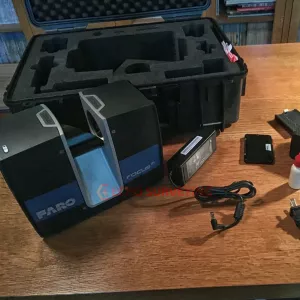
GeoSLAM ZEB-REVO for sale, GeoSLAM Hub Software with Licence dongle, 1 Year Geoslam Warranty
GeoSLAM ZEB-REVO sale package:
- GS_610042 Geoslam ZEB-REVO handheld laser scanner
- GS_610048 Geoslam ZEB DL-2600 data logger
- GS_610008 Geoslam ZEB REVO main cable
- GS_610024 Geoslam ZEB DL-2600 download cable
- GS_USB USB 8GB memory stick
- 12v Auto socket charger
- GeoSLAM Hub Software with Licence dongle, USB stick containing Installation & User Guide, Software Support & Maintenance
- Backpack
- 1 year hardware warranty
GeoSLAM ZEB-REVO Parts
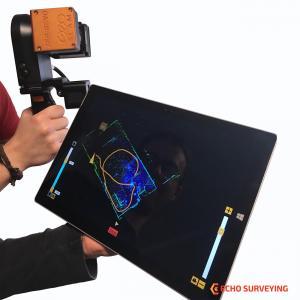
GeoSLAM ZEB-REVO Mobile 3D Scanner, Hand-held, Lightweight and Easy-to-use, ”Go-anywhere” 3D mobile mapping technology that allows you to rapidly build high-accuracy 3D models within minutes, while on the move
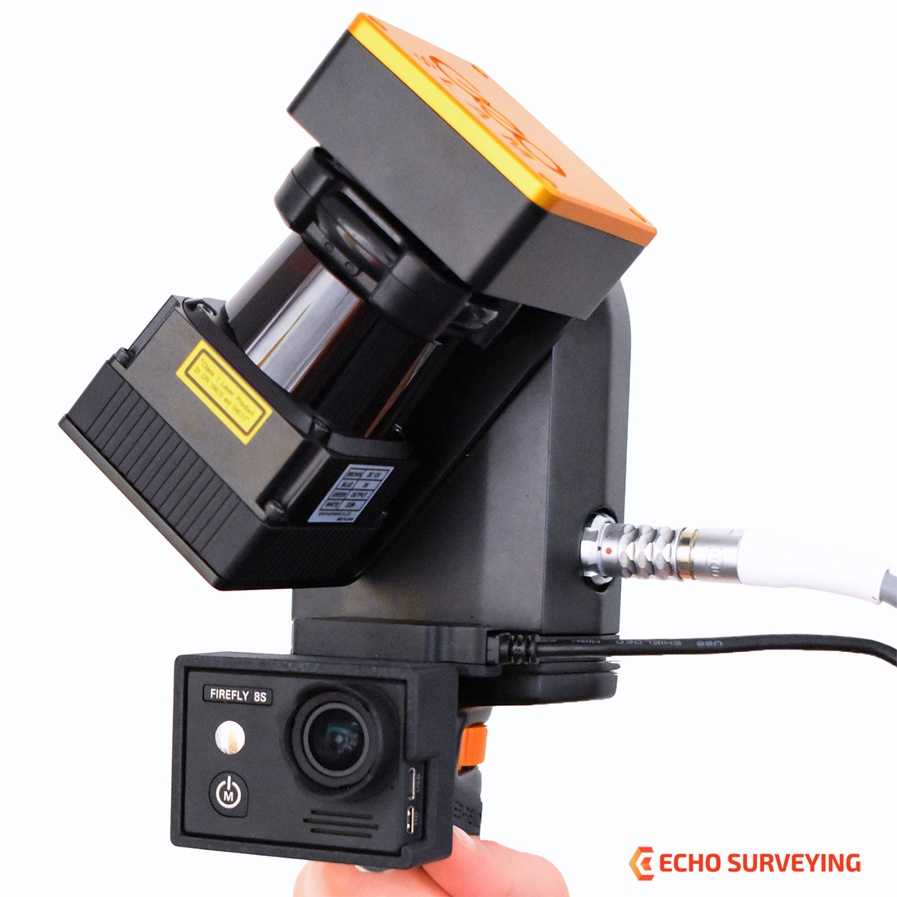
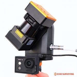
Optional add-on video camera GeoSlam ZEB-CAM Firefly 8S for the ZEB-REVO. ZEB-CAM incorporates a Hawkeye Firefly 8S action video camera. The image data collected by the camera can be viewed alongside the 3D point cloud created by the ZEB-REVO and used to extract contextual information. Simply attach the ZEB-CAM to the underside of your standard REVO unit and begin scanning. ZEB-CAM captures live video footage of your survey environment as you walk and scan. Optical flow technology is utilised to accurately synchronise the video and scan data together in GeoSLAM’s Hub software.
FEATURES
- Lightweight, handheld laser scanners which are highly mobile, simple to operate and can be used by anyone. Our versatile technology is adaptable to any environment, especially complex and enclosed spaces, without the need for GNSS. The 100Hz surveying system includes scanner, data logger and accessories and enables you to accurately scan and capture data, while on the move.
- User-friendly desktop software which turns data into real-time 3D information, delivering rapid and accurate results within minutes. With unlimited point cloud processing software and local registration, you can check your survey data instantly on site and export files in a range of industry standard formats.
- Support & maintenance options depending on what your business needs – including helpdesk, issue analysis and resolution, product enhancement and release management.
Data capture with the ZEB_REVO is as simple as ‘walk and scan’. Map a 3-storey building in just 30 minutes to an accuracy level of ±15mm or scan, view and export up to 10,000 m2 in under 1 hour. Join our customers as they measure building plans 10 times faster than traditional tools, deliver BIM models earlier than expected and experience project cost savings of up to two thirds. And with this solution, customers can expand their range and scope of services by taking on projects that would otherwise have proved too difficult or time consuming using traditional survey techniques.
INDUSTRIES
- Surveying: The role of the modern surveyor is rapidly changing as demands grow to quickly and accurately capture, manage and utilise spatial information. Many surveyors need to work in hazardous environments (with deteriorating floors or derelict buildings), as well as complex and difficult to access spaces where there is limited or no GPS coverage (such as heritage buildings with thick stone walls). And they will often have a very limited time on site to accurately create a 3D model. Access to user-friendly technology that can quickly scan multi-level environments and produce accurate and high quality data can be a game-changer for surveyors.
- Engineering: Throughout the engineering lifecycle, from design to construction and maintenance, civil engineers today need to accurately capture, manage and utilise spatial information. Many engineers work in enclosed environments (tunnels, mines, power stations), as well as complex and difficult to access spaces where there is no GPS coverage (bridge towers, underground stations & tunnels). They will often have a very limited time on site to accurately create actionable 3D models; and for on the job quality control, they’ll need to regularly compare the situation on the ground to the digital model. With digital engineering being the building block for 21st century construction, access to user-friendly technology that can quickly scan multi-level environments and produce accurate and high quality data is a game-changer for engineers.
- Facilities & Asset Management: The demand for up to date, accurate 3D models is greater than ever before. Traditionally creating these models was solely the domain of professional surveyors, but now engineers and geospatial professionals such as facilities managers and architects are all seeking ways to quickly and accurately create 3D models. Asset managers too are discovering the advantages of recording properties as well-defined features. These professionals all need access to user-friendly technology that is easy to install and use, but is robust and reliable enough to do the job quickly and accurately. For those working in difficult to access spaces where there is no GPS coverage such as inside buildings, remote locations, underground, the demands on the technology are even greater. And for many, mapping the space is time critical. Access to user-friendly technology that can quickly scan multi-level environments and produce accurate and high quality 3D data can be a game-changer for facilities managers, architects and asset managers.
- Mining: Mapping the underground world, for prospecting, exploiting or using mineral deposits is one of the most complex forms of surveying. Most environments are hazardous, and mining professionals need to work in tight, enclosed spaces, which can be complex and difficult to access. And of course, GPS coverage is non-existant. Despite needing to rapidly map mines under intense time constraints, traditional underground survey techniques have proved to be slow. Professionals all need access to user-friendly technology that is easy to install and use, but is robust and reliable enough to do the job quickly and accurately. They need tools that enable them to survey an underground or difficult to access space and within minutes build a highly accurate 3D model of that space.
- Forestry: Monitoring and understanding our environment has never been more important as the threat of climate change looms and governments step-up to better manage their emissions of greenhouse gases. Establishing accurate 3D maps of planting, harvesting and deforestation are all vital activities for environmental and forestry agencies. But many of these forest spaces are complex and difficult to access. Precise scans that take readings from even the densest of areas are required. And notably in most forests there is no GPS coverage. Forestry professionals all need access to user-friendly technology that is easy to install and use, but is robust and reliable enough to do the job quickly and accurately. They need tools that enable them to survey outdoor, complex or difficult to access spaces and within minutes build a highly accurate 3D model
SPESIFICATIONS
- Data Acquisition Speed: 43,200 measurement points/sec
- 3D Measurement Accuracy: +/- 0.1% (typically)
- Maximum Range: Up to 30m (15m outdoors)
- Laser Safety Class: Class 1 Eye Safe
- Angular Field of View: +270 x ~360 degrees
- Weight of Scanner Head: 1.0 kg
- Dimensions of Scanner Head: 86 x 113 x 287mm