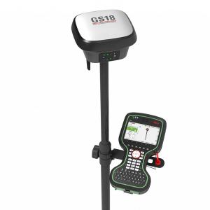
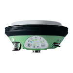


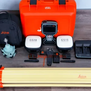
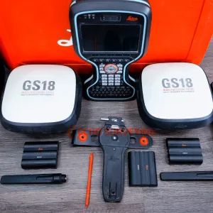
Sale Leica GS18 T LTE Base Rover GPS GNSS Galileo Tilt RTK CS20 System, both GS18 T LTE receivers have 20Hz update rates and feature internal Satel TR4 UHF radios and 4G cell modems
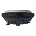
The Leica GS18s are T/LTE & UHF Performance models and feature TILT using the internal IMUs, the Leica CS20 has Captivate 4.50 currently installed. The collector does have an internal LRBT radio for various Robotic operation.
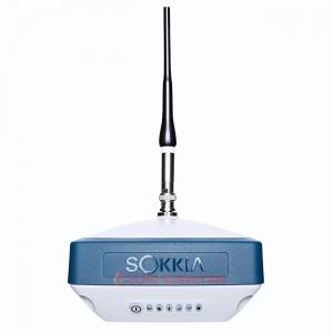
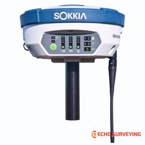
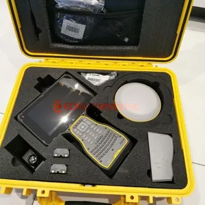
Sale includes:
Leica GS18 T IS the original truly tilt compensating GNSS solution that is immune to magnetic disturbances and is calibration-free. The sensor fusion of GNSS and Inertial Measurement Unit (IMU) creates the original true tilt compensating GNSS smart antenna. For GS18, T means tilt. As you no longer need to watch and level the bubble, you can focus on your task at hand and save time. The GS18 T works directly out of the box without any calibration procedure and like most of the Leica Geosystems GNSS Smart Antennas, you can use it as a rover and a base.
Leica GS18 T, the fastest and easiest-to-use GNSS smart antenna and RTK rover. This latest innovation combines GNSS and inertial micro units (IMUs) to be the first true tilt compensation solution immune to magnetic disturbances and is calibration-free. As you no longer need to watch and level the bubble, you can focus on your task at hand and save time over conventional surveying practices. Uninterrupted, accurate positioning when surrounded by or in close proximity to metallic objects - measure where others simply couldn’t before. The GS18 T works directly out of the box without any calibration procedure.
With integrated quality assurance, this GNSS RTK rover records how the pole was levelled during the measurement and stores the values, ensuring measurement traceability and complete quality reporting.
Customer care at a click
Through Active Customer Care, a global network of experienced professionals is only a click away to expertly guide you through any problem.
Powerful handheld devices
In a controller or tablet, take your entire office on the go when you discover the power to overcome any environment from the palm of your hand. The Leica CS20 controller and Leica CS35 tablet provide the ultimate in control and convenience with complete mobility. Touchscreen technology allows for comfortable and quick data processing while a stunning 3D view transforms your GNSS experience
Leica Geosystems GNSS Comparison Chart
|
|
|
|
|
|
|
||||||||||||||||||||||||||||||||||||
| Signal tracking |
Dual-frequency |
Dual-frequency |
Multi-frequency |
Multi-frequency |
Multi-frequency |
Multi-frequency |
|||||||||||||||||||||||||||||||||||
|
|
|
|
|
|
|
|||||||||||||||||||||||||||||||||||
|
|
|
|
|
|
|
|||||||||||||||||||||||||||||||||||
| Tilt compensation |
|
|
|
|
|
|
|||||||||||||||||||||||||||||||||||
| Single baseline RTK |
Hz 10 mm + 1 ppm / V 20 mm + 1 ppm |
Hz 8 mm + 1 ppm / V 15 mm + 1 ppm |
Hz 8 mm + 1 ppm / V 15 mm + 1 ppm |
Hz 8 mm + 1 ppm / V 15 mm + 1 ppm |
Hz 8 mm + 1 ppm / V 15 mm + 1 ppm |
Hz 8 mm + 1 ppm / V 15 mm + 1 ppm |
|||||||||||||||||||||||||||||||||||
| Network RTK |
Hz 10 mm + 0.5 ppm / V 20 mm + 0.5 ppm |
Hz 8 mm + 0.5 ppm / V 15 mm + 0.5 ppm |
Hz 8 mm + 0.5 ppm / V 15 mm + 0.5 ppm |
Hz 8 mm + 0.5 ppm / V 15 mm + 0.5 ppm |
Hz 8 mm + 0.5 ppm / V 15 mm + 0.5 ppm |
Hz 8 mm + 0.5 ppm / V 15 mm + 0.5 ppm |
|||||||||||||||||||||||||||||||||||
| Static (phase) with long observations |
Hz 3 mm + 0.5 ppm / V 6 mm + 0.5 ppm |
Hz 3 mm + 0.1 ppm / V 3.5 mm + 0.4 ppm |
Hz 3 mm + 0.1 ppm / V 3.5 mm + 0.4 ppm |
Hz 3 mm + 0.1 ppm / V 3.5 mm + 0.4 ppm |
Hz 3 mm + 0.1 ppm / V 3.5 mm + 0.4 ppm |
Hz 3 mm + 0.1 ppm / V 3.5 mm + 0.4 ppm |
|||||||||||||||||||||||||||||||||||
| Static and rapid static (phase) |
Hz 5 mm + 0.5 ppm / V 10 mm + 0.5 ppm |
Hz 3 mm + 0.5 ppm / V 5 mm + 0.5 ppm |
Hz 3 mm + 0.5 ppm / V 5 mm + 0.5 ppm |
Hz 3 mm + 0.5 ppm / V 5 mm + 0.5 ppm |
Hz 3 mm + 0.5 ppm / V 5 mm + 0.5 ppm |
Hz 3 mm + 0.5 ppm / V 5 mm + 0.5 ppm |
|||||||||||||||||||||||||||||||||||
| Reliability |
99,95% |
99,95% |
99,95% |
99,95% |
99,95% |
99,95% |
|||||||||||||||||||||||||||||||||||
|
|
|
|
|
|
|
|||||||||||||||||||||||||||||||||||
|
|
|
|
|
|
|
|||||||||||||||||||||||||||||||||||
| RTK reference station functionality |
|
|
|
|
|
|
|||||||||||||||||||||||||||||||||||
| Cellular / UHF Radio (receive & transmit) modem |
Controller internal |
3G |
3G |
4G |
3G |
3G |
|||||||||||||||||||||||||||||||||||
| Storage |
Controller internal |
MicroSD card |
MicroSD card |
SD card |
SD card |
SD card |
|||||||||||||||||||||||||||||||||||
|
|
|
|
|
|
|
|||||||||||||||||||||||||||||||||||
| Power, Bluetooth®, USB, RS232 |
|
|
|
|
|
|
|||||||||||||||||||||||||||||||||||
| Event, PPS |
|
|
|
|
|
|
|||||||||||||||||||||||||||||||||||
| Operating temperature -40°C to 65°C |
|
|
|
|
|
|
|||||||||||||||||||||||||||||||||||
| IP68 proof against water, sand and dust |
|
|
|
|
|
|
|||||||||||||||||||||||||||||||||||
| Weight (without battery) |
0.60 kg |
0.93 kg |
0.93 kg |
1.20 kg |
1.20 kg |
1.84 kg |
Downloads: